↗ View this article in the original PDF newsletter
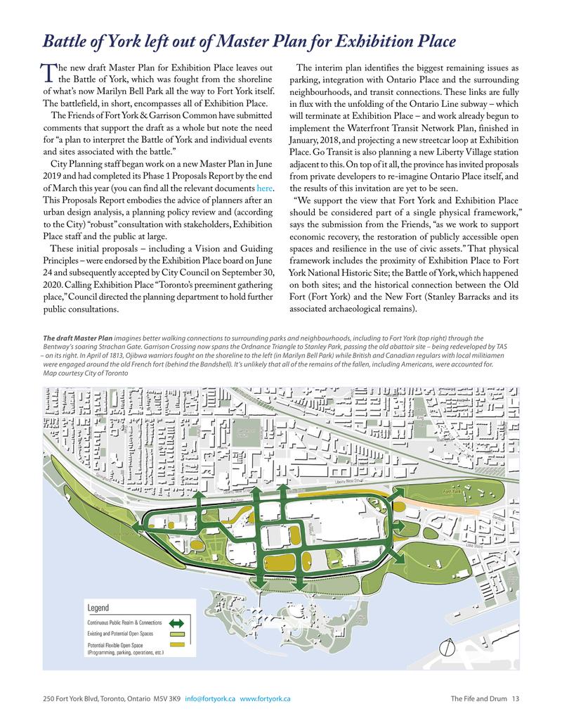
he new draft Master Plan for Exhibition Place leaves out T the Battle of York, which was fought from the shoreline of what’s now Marilyn Bell Park all the way to Fort York itself. The battlefield, in short, encompasses all of Exhibition Place. The Friends of Fort York & Garrison Common have submitted comments that support the draft as a whole but note the need for “a plan to interpret the Battle of York and individual events and sites associated with the battle.” City Planning staff began work on a new Master Plan in June 2019 and had completed its Phase 1 Proposals Report by the end of March this year (you can find all the relevant documents here. This Proposals Report embodies the advice of planners after an urban design analysis, a planning policy review and (according to the City) “robust” consultation with stakeholders, Exhibition Place staff and the public at large. These initial proposals – including a Vision and Guiding Principles – were endorsed by the Exhibition Place board on June 24 and subsequently accepted by City Council on September 30, 2020. Calling Exhibition Place “Toronto’s preeminent gathering place,” Council directed the planning department to hold further public consultations. The draft Master Plan imagines better walking connections to surrounding parks Bentway’s soaring Strachan Gate. Garrison Crossing now spans the Ordnance Triangle – on its right. In April of 1813, Ojibwa warriors fought on the shoreline to the left (in were engaged around the old French fort (behind the Bandshell). It’s unlikely that Map courtesy City of Toronto
The interim plan identifies the biggest remaining issues as parking, integration with Ontario Place and the surrounding neighbourhoods, and transit connections. These links are fully in flux with the unfolding of the Ontario Line subway – which will terminate at Exhibition Place – and work already begun to implement the Waterfront Transit Network Plan, finished in January, 2018, and projecting a new streetcar loop at Exhibition Place. Go Transit is also planning a new Liberty Village station adjacent to this. On top of it all, the province has invited proposals from private developers to re-imagine Ontario Place itself, and the results of this invitation are yet to be seen. “We support the view that Fort York and Exhibition Place should be considered part of a single physical framework,” says the submission from the Friends, “as we work to support economic recovery, the restoration of publicly accessible open spaces and resilience in the use of civic assets.” That physical framework includes the proximity of Exhibition Place to Fort York National Historic Site; the Battle of York, which happened on both sites; and the historical connection between the Old Fort (Fort York) and the New Fort (Stanley Barracks and its associated archaeological remains). and neighbourhoods, including to Fort York (top right) through the to Stanley Park, passing the old abattoir site – being redeveloped by TAS Marilyn Bell Park) while British and Canadian regulars with local militiamen all of the remains of the fallen, including Americans, were accounted for.
Battle of York left out of Master Plan
The submission from the Friends is focused on the report’s Cultural Heritage Landscape Assessment, which lacks any plan to interpret the battle. It’s also missing a plan to preserve and interpret Stanley Barracks “within a fully accessible publicrealm setting” (the site is now within the area leased by Hotel X). Interpretation should include the former Garrison Road, which connected the two forts in the nineteenth century. A suggestion that parking could be built below grade needs to be re-considered (adds the submission) in light of the importance of the battlefield and the possibility of encountering archaeological remains below ground. Another part of the interim plan is intended to “enhance and create new gateways linking the grounds to surrounding parks and open spaces.” About this, the Friends are suggesting improvements “to the public realm … immediately outside Exhibition Place along Strachan Avenue between Exhibition Place and Fort York National Historic Site.” Improvements here
should enable easier pedestrian movement between the two sites as well as an interpretation of Garrison Road. “The existence and ongoing development of The Bentway,” notes the submission, “has made this connection (between the east and west sides of Strachan Avenue) much more logical and easier to envision.” For its part, Fort York has already begun this with substantial upgrades to the parking lot at the corner of Fleet and Strachan; these include an interpretive wayfinding post near the site of the Western Battery and an earthen berm with perennial plantings to soften the edge of the parking. Two of the “quick start” initiatives proposed by the draft plan and supported by the Friends are at the Princes’ Gates and under the Gardiner Expressway. Finally, the Friends support further work on related economic opportunities and hope to be involved in the “cost/benefit analysis of implementing the heritage, parks and public realm strategies” proposed in the draft Exhibition Place Master Plan.

Original printed pages